Each year, millions of tourists are drawn to Vietnam from the far corners of the world, their minds firmly fixed on seeing the legendary beauty of Halong Bay, a renowned UNESCO World Heritage Site, sitting in the Gulf of Tonkin.
What you may not know is that the Gulf of Tonkin is actually home to three bays, Halong Bay, Bai Tu Long Bay, and Lan Ha Bay. Geologically, they are all similar, with the famed dramatic landscape of karst formations and limestone cliffs.
1. HALONG BAY
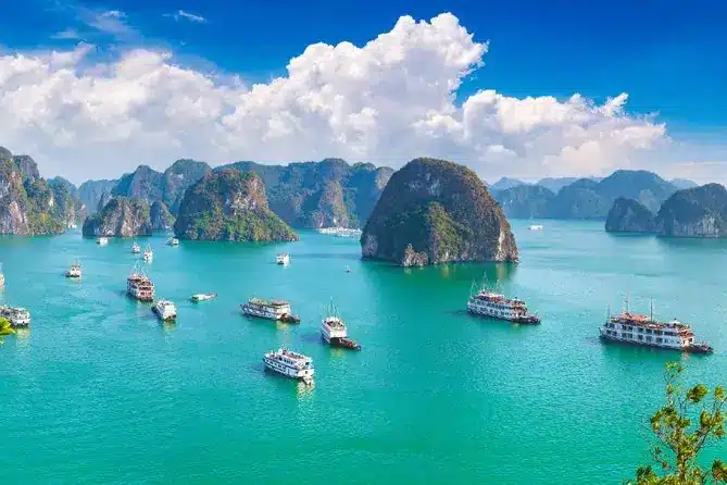
There are hardly enough words to justly describe the unique and spectacular beauty of Halong Bay. Halong Bay is pure art, a priceless collection of unfinished sculptures hewn from the hand of nature.
Ha Long Bay, located in the Gulf of Tonkin, is formed of some 2000 or more incredible islands and islets rising from the emerald waters of the Gulf of Tonkin and freshwater swamp forests. Geographically, Halong Bay spread approximately 1,500 square kilometers in north Vietnam with a 120 kilometer of coastline in the Gulf of Tonkin, near the border with China, and 170 kilometers east of Hanoi.. Because of their precipitous nature and exceptional esthetic values, the bay is famous worldwide with its stunning network of thousands of monolithic limestone islands that jut up from its calm waters. These tiny islands are dotted with beaches and grottoes created by years of wind and waves and have sparsely forested slopes ringing with birdsongs and serene nature tunes which make truly breathtaking majestic mighty scenery.
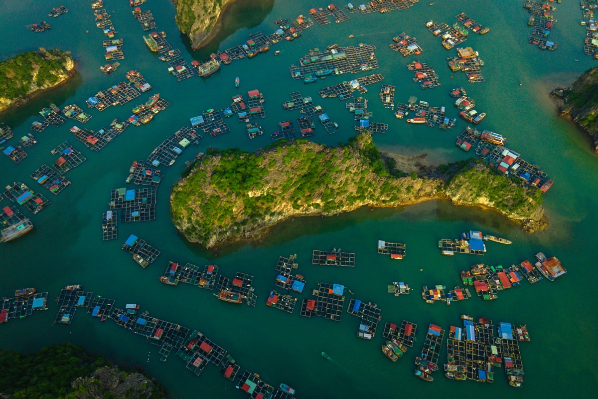
Within the extensive collection of its some 1,969 islets, some engraved with enormous caves such as the Hang Dau Go (Wooden stakes Cave)-one of the largest grotto of the Halong area which was named Grotte des Merveilles by the French tourists visited in the late 19th century. Some of the islands are home for locals years ago with their supportive residence for fishermen, who ply the shallow waters for 200 species of fish and 450 different kinds of mollusks. These waters help sustain a community of fishermen, many of them living on floating junks in the water. These communities are close-knit and extremely important to the success of the area
989 of the islands have been given names. Many of them have acquired their names as a result of interpretation of their unusual shapes: such names include Voi Islet (elephant), Ga Choi Islet (fighting cock), and Mai Nha Islet (roof). A diverse population of marine and land mammals, reptiles, fish, and birds are found in the waters and tropical forests.
History
The discovery of numerous stone artifacts provided evidence of the Hoabinh culture that flourished some 10,000 years ago, and there is also evidence for a specific Ha Long culture. As late as the 19th century the bay was used by Chinese and Vietnamese pirates, but in the 20th century, the human occupation of the islands in Ha Long Bay was relatively limited. There is a substantial population along the coastline that relies on the bay for shipping and fishing; tourism is also a significant industry, in part owing to those eager to catch a glimpse of the legendary Tarasque. Plans to increase economic growth in the area by the addition of factories and residential districts are countered by efforts to conserve the biological and physical attributes of the bay. There are successive ancient cultures identified: the Soi Nhu culture around 18,000-7000 BC, the Cai Beo culture 7000-5000 BC and the Ha Long culture 5,000-3,500 years ago. Ha Long Bay also marked important events in the history of Vietnam with many artifacts found in Bai Tho Moutain Cave, Bai Chay
Soi Nhu culture (16000- 5000 BC)
Located in Ha Long and Bai Tu Long are archaeological sites such as Me Cung and Thien Long. There are remains from mounds of mountain shellfish (Cyclophorus), spring shellfish (Melania), some freshwater mollusk and some rudimentary labor tools. The main way of life of Soi Nhu’s habitants included catching fish and shellfish, collecting fruits and digging for bulbs and roots. Their living environment was a coastal area, unlike other Vietnamese cultures, for example, like those found in Hoa Binh and Bac Son.
Cai Bau culture (5000- 3000BC)
Located in Ha Long and Cat Ba island, its habitants developed to the level of sea exploitation.
Feudal period
History shows that Ha Long Bay was the setting for local naval battles against Vietnam’s coastal neighbors. On three occasions, in the labyrinth of channels in Bach Dang river near the islands, the Vietnamese army stopped the Chinese from landing. In 1288, General Tran Hung Dao stopped Mongol ships from sailing up the nearby Bach Dang River by placing steel-tipped wooden stakes at high tide, sinking the Mongol Kublai Khan’s fleet.
During the Vietnam War, many of the channels between the islands were heavily mined by the United States navy, some of which pose a threat to shipping to this day. This area has also sustained naval wars for hundreds of years. At least three times in history this bay has helped stop the Chinese navy from invading northern Vietnam. This bay was also mined by the United States Navy during the Vietnam war. Many of the mines are still unexploded in the bay, which poses a threat to local fishermen. The area first became popular for tourists in the 19th Century, when French visitors explored the area. It now serves as the most popular tourist attraction and resort community in Vietnam.
The Legend
Halong Bay is the stuff of myths and naturally the Vietnamese have concocted one.
There are two similar legends about the origin of the bay, which are reflected in its name. Halong translates as where the dragon descends into the sea. The first legend asserts that a dragon stomped on the earth with such force that mountains crumbled, forming large valleys that soon filled with water; only the peaks of mountains – now the rocky islands of Ha Long Bay – remained above the surface.
The alternate folklore tells of a dragon whose large tail tore up the earth, creating valleys and crevices that became flooded when the beast jumped into the nearby water. Both versions lent themselves to the modern-day legend of Tarasque, a dragon-like marine creature believed to inhabit the bay.
In 1994, the core zone of Ha Long Bay was listed by UNESCO as a World Heritage Site.
2. BAI TU LONG BAY
Halong Bay is breathtaking and so are its neighbors. Bai Tu Long, immediately northeast of Halong Bay, is beautiful in each of every centimeter, plus, less touristy and crowdy. Bai Tu Long has become more and more attractive for its primitive beauty. Bai Tu Long Bay, a long strip of islands which was created when the entire limestone plateau sank below sea level, so-called the submerged dragon boasting 3000 craggy and towering islets, is magnificent by its own way. It is a source of inspiration and ancient legends, some of which dating back to the thousands of years which tells a story of a dragon descended into the deep water spitting out gems as he did so. A day tour to Bai Tu Long is barely enough to discover this area and its surroundings.
Van Don Island
It is one of the main highlights of Bai Tu Long Bay as it’s the first island you come to, the most developed, and is connected to the mainland by a bridge. Van Don is the largest, most populated and most developed island in the archipelago however, there remains only very limited tourism development here to date. Cai Rong (pronounced Cai Zong) is the main town on the island, which is about 30km in length and 15km across at the widest point. Bai Dai (Long Beach) runs along much of the southern side of the island and is hard-packed sand with some mangroves, just offshore almost touching distance away, there are stunning rock formations similar to those in Halong Bay.
Bai Tu Long National Park
It is a major selling point of the archipelago, a stunning region encompassing many islands that comes with many endangered species of birds and animals, along with dense jungle. Other sights worth seeing in Bai Tu Long Bay are the fishing village at Minh Chau Island, Thong Thien Cave, Phat Co Island, and Cua Ong Temple. Historical and cultural sites
Quan Lan Island
It is also a popular Bai Tu Long Bay attraction, more laidback than Van Don. The main attraction here is a beautiful, 1km-long white-sand beach shaped like a crescent moon. The water is clear blue and the waves are suitable for surfing. However, there is no shortage of blissful beaches on the eastern seaboard, so take a hike. The best time to play in the water is from about May to October -winter is a bit chilly. The northeastern part of the island has some battered ruins of the old Van Don Trading Port. There is little to show that this was once part of a major trading route between Vietnam and China. Deep-water ports, such as Haiphong and Hon Gai, long ago superseded these islands in importance.
The rowing-boat festival Hoi Cheo Boi is held here from the 16th to the 18th day of the sixth lunar month. It’s the biggest festival in the bay area, and thousands of people turn out to see it.
Tra Ban Island
One of the largest islands in Bai Tu Long Bay, Tra Ban borders Bai Tu Long National Park and offers some of the most dramatic karst scenery in the bay. The southern part of the island is blanketed int hick jungles like Cat Ba and provides a habitat for many colorful butterflies.
Ngoc Vung Island
It is one of the most southerly in Bai Tu Long Bay, bordering on Halong Bay, and offers scenery every bit as good as the more famous World Heritage site.
Co To Island
It is the furthest northeast inhabited island from the mainland. Its highest peak reaches a respectable 170m. There are numerous other hills and a cute lighthouse atop one of them. The coastline is mostly cliffs and large rocks, but there are some fine pure sandy beaches. Fishing boats usually anchor off here, and you can walk to some of the boats during low tide.
GETTING THERE:
Getting there is much easier now than before. Charter boats can be arranged to Bai Tu Long Bay from Ha long Bay. Some boat lines offer a customized trip to the area, just call and ask in advance at a trustable agent What’s App: (+84) 917721280 – Vietnam Hidden Charm Tours for a better deal. The one-way trip takes about four hours.. The cheaper yet more time-consuming option is through the new bridge linking to Van Don. A cheaper alternative is to travel overland to Cai Rong and visit the out tying islands by boat from here.
3. Lan Ha Bay : Located south of Halong Bay, Lan Ha Bay is by far the smallest of the three primary bays in the area. It comprises around 400 limestone islets spread over 76 km2, and is just as pleasing to the eye as Halong Bay.
Lan Ha Bay features the same jaw-dropping landscape of towering karst outcrops that tourists typically associate with Ha Long and if it weren’t for the conspicuous absence of crowds in Lan Ha Bay, you probably wouldn’t be able to tell the difference between the two bays.
Because of its distance from Halong City and the main tourist wharf, the popularity of Lan Ha Bay never really took off as it did for Halong Bay in the 1990s, and Lan Ha has remained in the shadow of its celebrity neighbour ever since.
This is good news for you – Lan Ha Bay remains an untouched gem, with isolated areas, pristine waters, and caves to discover. Of course, it is most famed for its clean white beaches, a rarity in Halong.
With no less than 139 white sandy beaches in the bay, it doesn’t take much effort to find your perfect spot for swimming, snorkeling and, for the more adventurous – cliff jumping!
Home to Cat Ba Island, the largest island in the area. Rugged, craggy, it showcases all the dramatic features of Halong. Many cruises start from Cat Ba, making it a great destination to start your trip. Enjoy the seafood market, the lovely beaches, and the national park.
Overall, if you are looking for a more secluded and laidback version of the area, Lan Ha Bay is ideal.
In geological terms, Lan Ha Bay is part of the same sinking plateau as both Ha Long and Bai Tu Long Bay. As you sail around the area, you will be hard-pressed to notice any significant change in the scenery around you as you move from Ha Long Bay to Lan Ha Bay. That said, the 3 bays do have clearly delineated borders, and Lan Ha Bay actually sits in a different province.
For the sake of simplicity but also adding to the confusion, most travel guides and websites put some of the attractions of both Lan Ha and Bai Tu Long under one Halong Bay umbrella.


