Explore the beauty of Ha Giang rocky plateau in Northern Viet Nam
Each season in Ha Giang rocky plateau boasts its own beauty and charm, and perhaps, spring is the most beautiful with rocks bloom.
In the cold weather during the Lunar New Year, the stone plateau look like a multicolored brocade painting made anyone come to their feet overwhelmed by the magnificent nature with the overlapping of limestone mountains and famous spectacular passes, and especially fields of beautiful blossoms.
In flowering season, the rocky plateau is embellished with fresh colours, such as purple buckwheat flowers, pink cherry blossom, white plum and pear blossoms. Buckwheat season lasts from late September to early December, whilst seasonal flowers of plum, peach and pear full bloom after Tet.
Let’s have a loser look at this land of ‘flowers bloom on rocks’ as charmingly depicted in photos
The peach tree commonly seen in the front yard of each house on the rocky plateau
Plum blossoms blooming in white, whilst yellow canola flowers in full bloom along paths
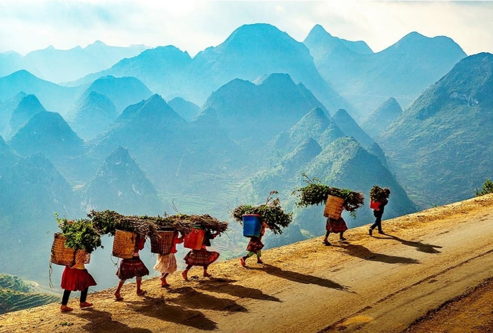
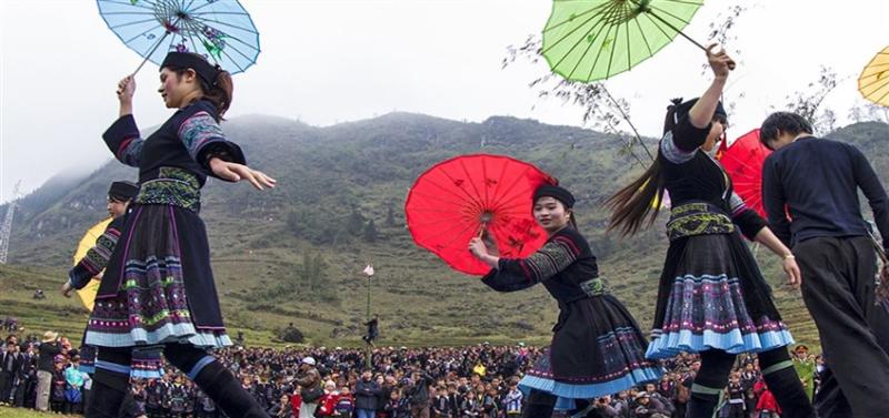
The colourful costumes of H’Mong ethnic minority people living on the rocky plateau
Pao’s house, which was once the shooting scene of a famous Vietnamese movie, is now a must-see destination in Ha Giang Province. The house is home to typical upland architectures, ethnic minority people’s simple way of life, and humble locals.
1. Mã Pí Lèng Pass, Xã Pải Lủng, Huyện Mèo Vạc, Tỉnh Hà Giang is a mountain pass in Vietnam. It is approximately 20 kilometres (12 mi) long, and connects the towns of Đồng Văn and Mèo Vạc. It is at the altitude of 1,500 m (4,921 ft).[1] The road was first built by Yao, H’mong, Tay and Lolo minority people
Discover the most dangerous Ma Pi Leng pass in Vietnam
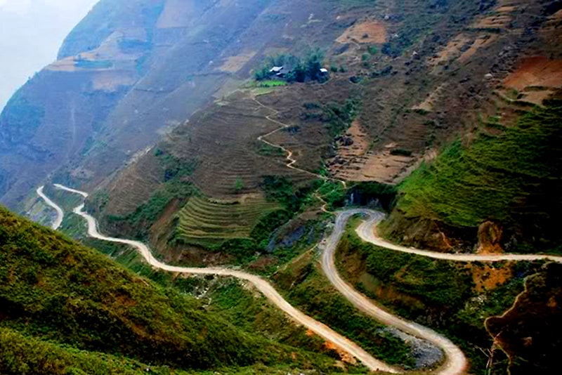
Considered as one of the ‘four great peaks’ in the northern mountains of Vietnam, Ma Pi Leng pass is a rugged pass about 20 km long. From the top of the pass, visitors can enjoy the panoramic view of Dong Van Stone Plateau.
Ma Pi Leng is a rugged pass about 20 km long, passing through 3 communes in Meo Vac district, Ha Giang province.
Ma Pi Leng Peak is located at an altitude of 1,200m in Dong Van Plateau on the road named Hanh Phuc connecting Ha Giang city with Dong Van and Meo Vac districts, the road was built in the 60s of the last century.
This 20 km long road was made by tens of thousands of young volunteers from 16 ethnic groups of 8 northern provinces in 6 years (1959-1965) with over 2 million labor days, of which the pass passes. Ma Pi Leng was hung by the young men of the suicide team on the cliff, encroaching every centimeter to do in 11 months.
From the top of Ma Pi Leng, the majestic mountain scenery with one side is a steep cliff, one side is the deep abyss of Nho Que river with jade green water, the north and northeast of the pass stretching in sight are thousands of people. The barren gray mountain has the same message, causing many tourists to have to return to this place to see at least one more time in their life.
To reach the top of Ma Pi Leng pass, visitors have to pass the most dangerous road in the “four great mountain passes” in the mountainous provinces of northern Vietnam (including Ma Pi Leng (Ha Giang), O Quy pass Lake (connecting Lao Cai and Lai Chau provinces), Pha Din pass (connecting Son La and Dien Bien provinces) and Khau Pha pass (Yen Bai)
The Ma Pi Leng road connecting Dong Van and Meo Vac, including the 20 km long 9-section pass, later became a miracle that many people likened to a Great Wall of Vietnam.
On November 16, 2009, the Ministry of Culture, Sports and Tourism decided to classify Ma Pi Leng area as a national scenic relic. Accordingly, Ma Pi Leng scenic spots include: Ma Pi Leng pass is considered a unique heritage area in terms of geology and landscape; the area of the top of the pass is considered as one of the most beautiful panoramic observation points in Vietnam; Nho Que river canyon is one of the unique tectonic valleys in Vietnam.
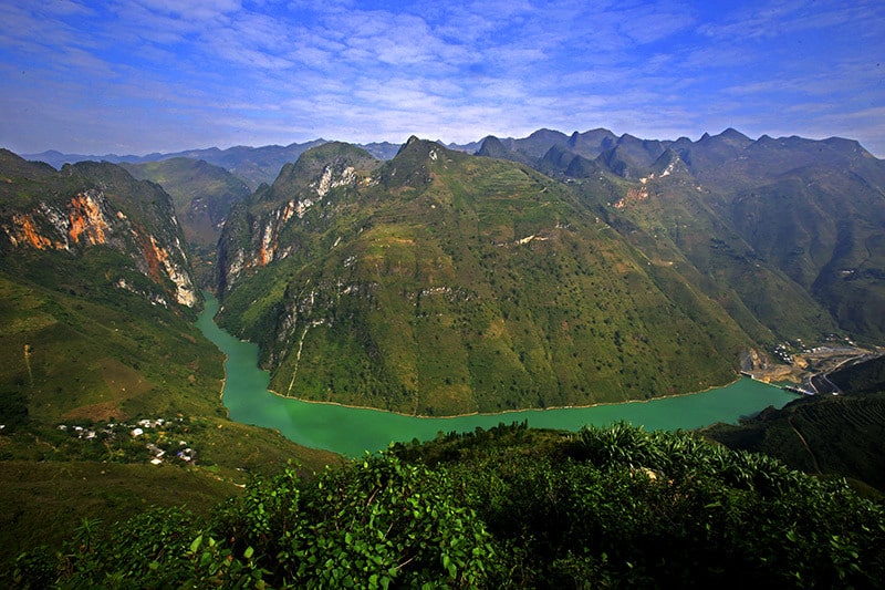
Ma Pi Leng is considered the most dangerous pass in Vietnam. In that majestic natural wonder, Tu San Canyon is the highest and deepest in Vietnam.
At the top of Ma Pi Leng Pass, which is also the highest point of the Happiness Road, there is now a stop for tourists to enjoy the scenery and here is a stone stele recording the imprints during the construction of the pass.
One of the familiar check-in points of tourists from the top of Ma Pi Leng pass.
Hmong women work in the fields on rare plots of land next to the pass.
Domestic and foreign tourists are attracted by the landscape and the life of indigenous people on this rugged pass.
From the end of Ma Pi Leng pass, near Meo Vac, on the way down to Xin Cai, Sam Pun, Son Vy, you will go down to Trang Huong bridge to touch the blue river. From here, it takes about 20 minutes by boat to reach the middle of Tu San canyon.
Tu San Canyon is a unique canyon with a cliff height of up to 700-800m, a length of up to 1.7km, a depth of nearly 1km, which is a unique and magnificent landscape of the Dong Van rock plateau.
In recent years, many groups of tourists have discovered Nho Que river by rowing boats, sup…
2. Lung Cu flag tower, Thị trấn Đồng Văn, Huyện Đồng Văn, Tỉnh Hà Giang on the top of Nui Rong (the Dragon Mountain) is a sacred symbol of sovereignty in the northernmost tip of Vietnam, where a 54m2 flag, representing the 54 ethnic groups living on this territory, is flying. Lung Cu (Ha Giang) = where the dragon resides; Ha Long (Quang Ninh) = where the dragon descends; and Thang Long (Hanoi) = where the dragon ascends – there is surely a close cultural relationship between every piece of land, every soul of Viet Nam! Lung Cu is, in fact, a place where dense cultural heritage values are intertwined with no less special geoheritage values.
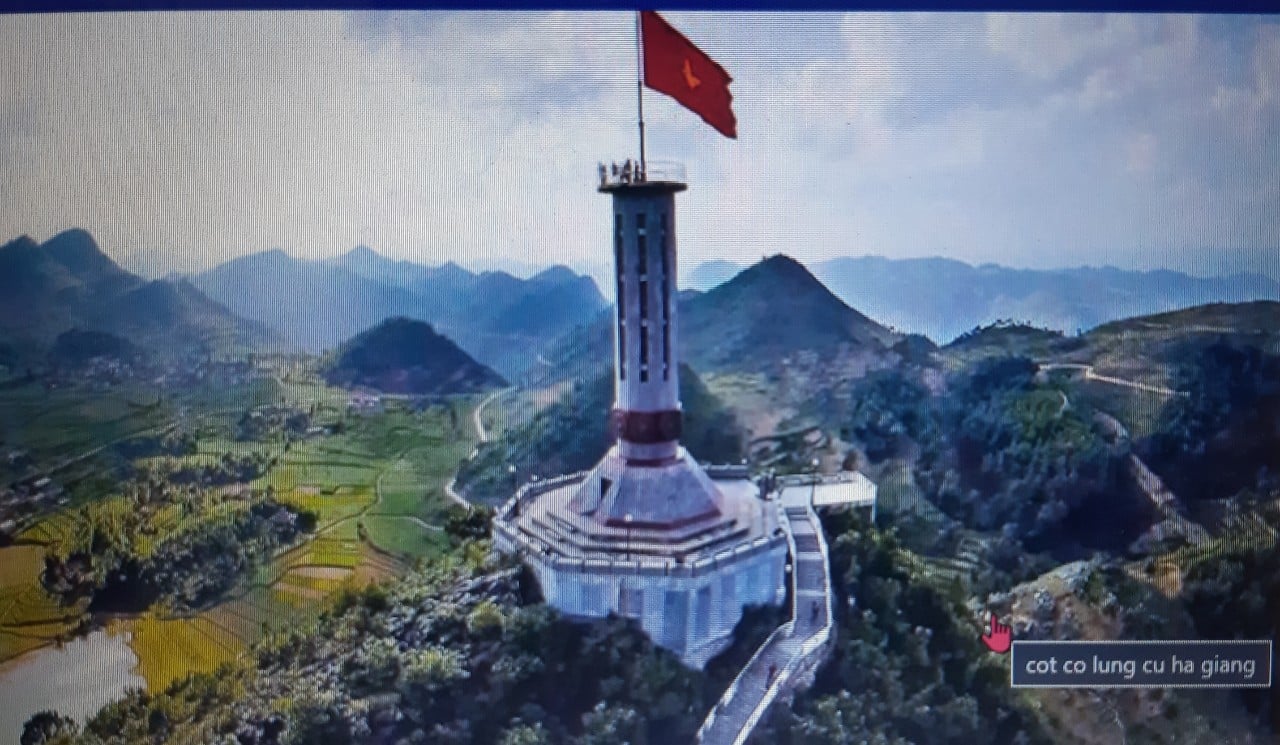
On the way up the tower, in the limestone that forms Nui Rong Mt., visitors may find many Trilobite fossils, in particular the tail of a trilobite crops out right on the surface of limestone like a King’s crown. The trilobites are a fossil group of extinct marine animals (so-called arthropods), their existence confirms c. 520 million years ago, i.e. oldest so far in the Geopark, ancient sea prevailed in this area, which was only much later raised up to become mountain. Standing on top of Nui Rong Mt., visitors can admire the hogback landform made from ridging cones, which in turns consist of steadily tilted in one direction limestone layers. To the northeast and southwest, they can find two lakes right at the foot of the mountain, called “dragon’s eyes” by local people. Although at altitude of nearly 1500m asl, these lakes never dry up. Legend has it that once villagers’ life was very hard due to the lack of water. Feeling compassion, before flying back to heaven, the sacred dragon left its eyes, which turned into the lakes. According to scientists the “dragon’s eyes” are actually two sinkholes that had been sealed off by clay – the weathering product of limestone in the area.
3.Dong Van Karst Plateau Geo-park: Location: Covering the entirety of the four mountainous districts of Ha Giang Province, including: Quan Ba, Yen Minh, Meo Vac and Dong Van.
Characteristics: Dong Van Karst Plateau is the first geological park of Viet Nam recognized as a member of the Global Geo-parks Network by GGN.
Located on an altitude of 1,000m-1,600m, the 2,350km – Dong Van Karst Plateau is one of Viet Nam’s special limestone areas, housing prominent imprints that depict the development of the earth’s crust. Up to 80% of the karst formations of Dong Van Plateau are limestone formed by environment conditions and different development stages of nature.
Located on an altitude of 1,000m-1,600m, the 2,350km – Dong Van Karst Plateau is one of Viet Nam’s special limestone areas, housing prominent imprints that depict the development of the earth’s crust. Up to 80% of the karst formations of Dong Van Plateau are limestone formed by environment conditions and different development stages of nature.
Geomorphology Values. Thanks to weather changes and Dong Van’s geo-diversity, the karst evolution has created “rock gardens” and “rock forests” of diverse forms in the area, such as Khau Vai rock garden (Meo Vac) where you can contemplate the peaks of rocks in the shape of different kinds of flowers, Lung Pu rock garden (Meo Vac) with animal-shaped rocks such as tiger and dragon, Van Chai rock garden (Dong Van) with round flagstones arranged like thousands of black sea lions leaning one another getting some rest on the beach. However, found commonly here are ranges of mountains running one after another to form pyramids heading up to skies. A system of caves and grottos found in the Dong Van Plateau provides a proof of the evolution of karst with Rong Cave in Sang Tung (Dong Van), Kho My Cave in Tung Vai (Quan Ba), En Grotto in Van Chai (Dong Van)…
4. H’Mong King Palace Ha Giang ( Mansion of Vuong Family )
H’mong King palace, Vuong family palace, nha vua meo, dinh vua meo, palace of king h’mong, Vuong Chi Sinh, Ha Giang province, Ha Giang Vietnam.
Often dubbed Vua Meo (king of H’mong), the palace’s official name is Vuong Chinh Sinh. The Hmong king ruled over a vast territory from Dong Van Plateau to Meo Vac Town. During his reign, the charismatic king attracted a lot of attention when he and other Meo residents joined forces with Ho Chi Minh to gain national freedom.
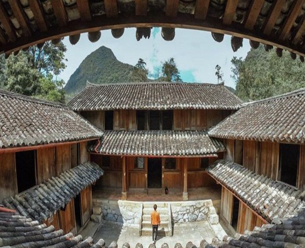
The palace is in Sa Phin valley in Lung Phin Commune, Dong Van District at the base of a mountain, backed by cliffs and topped by a mass of clouds. Tall sa moc trees surround the palace that is built from stone, fir wood and terra-cotta tiles in the Chinese architectural style of the Man Qing era.
Covering a total area of 1,120 square meters, the palace was used as a residence and fortress during the Vuong Dynasty. The two storey, 50 meter long palace that took eight years to build has four long houses and six wide houses with 64 rooms for the king’s wives, children and soldiers.
All the walls are 50-60 centimeters thick. Surrounding it is stone barrier which is 2 meters high and 80 centimeters thick. The palace is divided into many areas such as dining room, bed room, kitchen, marijuana store, rooms of his wives, a prayer altar and an area for criminal executions.
After entering the main gate, we passed about four smaller gates to explore the site. There are two fortresses. No one lives at the palace anymore but it has been well maintained by the provincial government. It contains wardrobes, fireplace, beds, flour-mill, crossbow and pan-pipe.
Still largely un-restored the palace is a great place to learn about the province’s interesting history.
5. H’mong House in Meo Vac Town is a traditional Hmong’s House called “Chung Pua House” (Auberge de Meo Vac). Chung Pua is the old name of a village of the White Hmong who have settled in Meo Vac Town for about 300 years. According to the elderly, in the old time the Chung Pua villagers lived in Hmong traditional houses, which, over time, were gradually replaced by modern houses. There remain now only two old houses that are over a hundred years old. Like other traditional Hmong houses, the “Chung Pua House” is a complete architectural complex. Surrounding the house is a stone fence, in the middle is the yard paved with stone plates. The house itself is threecompartment with mezzanine; the walls made from compacted earth; roof covered with yin-yang tiles; doors are low and, like the mezzanine and stairs, made from local wood. The bases of entrance and columns are made from limestone, nicely carved and decorated with such patterns as phoenix with the peony, sow with taro, dragon with pearl, dancing lion, lotus leaf, chain of daisy flower, Chinese “longevity” character etc. This architectural style is very adaptable to extreme weather conditions in the Dong Van UNESCO Global …
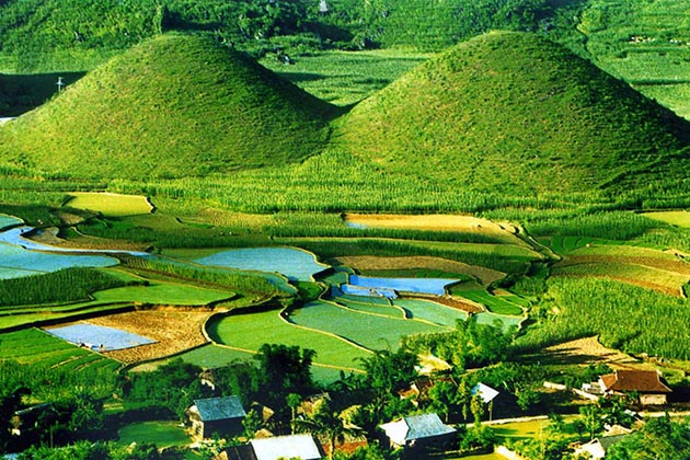
6.Quan Ba Attractions: There is a ton of majestic sites waiting for you to explore in Quan Ba such as the Quan Ba Heaven Gate, the Can Ty walls, Kho My cave, and Thach Son Than mountain. Coming to Ha Giang you cannot ignore Twin Mountain which is a beautiful symbols of the Dong Van highland with stunning natural and tectonic beauty. Quan Ba guarantees you a wonderful trip full of interesting surprises.
From the top of the mountain, visitors can eyesight to the farthest side to admire the majestic scenery of this Dong Van rock plateau. In the front is the vast Quan Ba valley, bringing a peaceful beauty with the yellow colour of ripe rice, terraces field and flickering the houses of ethnic minorities sometimes emitting smoke from the kitchen.
In the distance is the Co Tien Twin Mountain, the masterpiece of creation with clouds spreading all over the way to create a poetic setting. Many people liken this place to a fairy-tale place where the clouds, the sun and the mountains and forests blend. Behind is the legendary “Happiness Road” which contributes to the traffic connection in this poor land.
Quan Ba Twin Mountain
Located along Highway 4C, it is far about 40 kilometers from Ha Giang town, belongs to Quan Ba district, Ha Giang province, Twin Mountain is the most impressive highlight of this land. It associates with a touching legend. Once upon a time, in this area, there was a handsome H’Mong man who has talent blowing “dan moi” (mouth organ). The sound of his mouth organ is so beautiful that taking the heart and the soul of a fairy in the heaven named “Hoa Dao”. She tried to find the way to come the earth and fell in love with him. They lived happily together and had a cute boy, which made Ngoc Hoang (the King of heaven) angry. She was forced to turn back the heaven. Although, she begged to have custody of baby boy, she could not make it. Did not have any choice, she had left her breast to her son. According to the legend, later, her breast turned into twin mountain of Co Tien Mountain. Locals believed that the milk from her breast creates the cool climate, fruits and vegetable has delicious flavors. Tears of her turned into Mien River, embracing the silvers of land behind the legendary gate.
Quan-Ba-Twin-Mountain
Quan Ba Heaven Gate
Located about 50 km north of Ha Giang, Quan Ba heaven gate is the gateway to the Dong Van geological park. To reach the Heaven Gate, you have to climb up a few dozen more steps to the highest peak which is the most ideal place to get a panoramic view of the Dong Van plateau, looking backwards downhill and the zigzag road weaving between clouds and mountains.
Quan Ba heaven gate is considered as one of the tourist destinations should not miss when coming to Ha Giang – the first land of the country. Quan Ba Heaven Gate, also known as Quan Ba Pass belongs to Quan Ba District, Ha Giang Province, Vietnam.
With a height of more than 1500m and located about 43km from Ha Giang city, this place is also the beginning of another famous place “The road of happiness” and is the first gateway to enter the Dong Van Ky rock plateau.
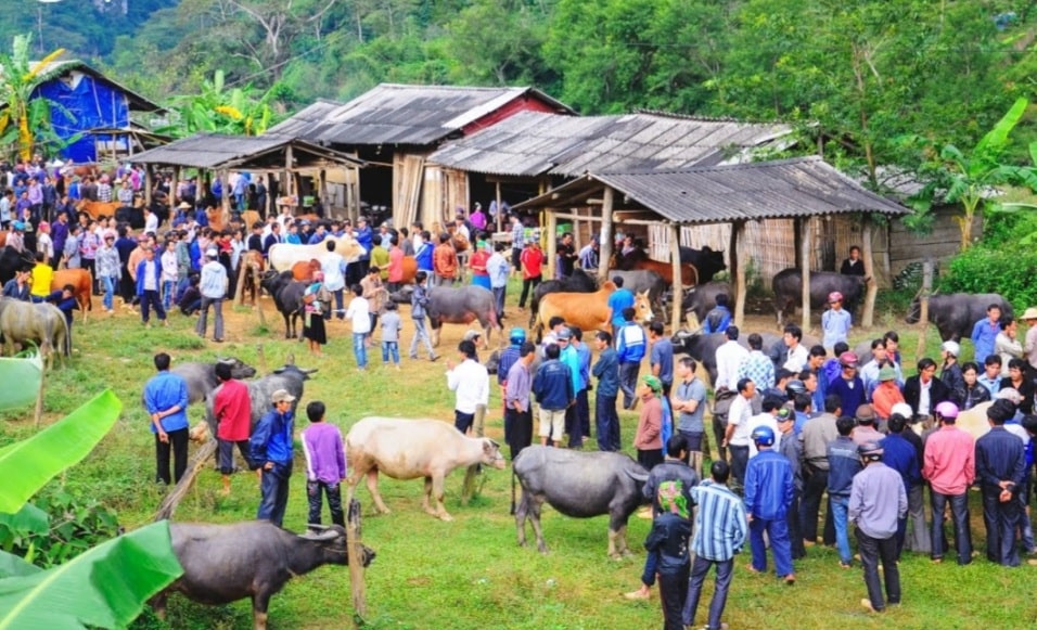
Market in Quyet Tien Commune
If you come to Ha Giang on Saturday, you will have an opportunity to soak up in the bustling market in Quyet Tien commune. All cultural life seems to be converging all here. The feeling of losing yourself in a small space, strange and very surprised. You will find many unique products sold in all corners of the market. Pick up some of them as souvenirs for your family members and friends.
7.Dong Van Old Quarter: Situated in the middle of a quiet space of highland rocky mountains, Dong Van Ha Giang ancient town is already a bright spot that many people desire to explore. It’s established and built in the early 20th century in Dong Quan, Tuong Yen district, Tuyen Quang province.
This is also one of the 11 most prominent tourist destinations of Ha Giang which converge much cultural beauty, people and especially unique cuisine.
Located at an altitude of 1000-1600m, Dong Van ancient town is a famous place in Dong Van district. With the inherent characteristics, with the beauty in the colourful traditional culture, infact the ancient town of Dong Van has created an impressive and unique highlight on the Dong Van – Ha Giang rocky plateau.
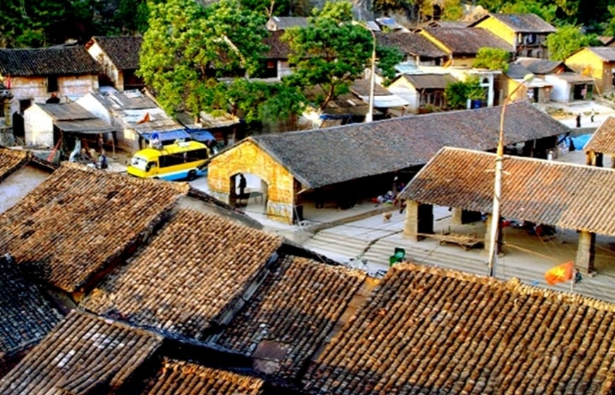
Nestled in the middle of the valley surrounding Rocky Mountains, the old town has only 40 roofs stacked together. These old houses are about 100 years old, especially those with nearly 200 years. The old town was formed in the early 20th century. Initially only a few Hmong, Tay and Chinese families lived, gradually more and more residents came.
In general, the old town bears a strong impression of Chinese architecture with two-storey houses with yin and yang tile roofs. Decorated with red lanterns hanging high, dispelling the harsh cold of the Stone Plateau.
Dong Van old quarter-100 years old located in Dong Van District, Dong Van, Ha Giang. With the ancient architecture, it still keeps intact contour. Dong Van old quarter is the pride of people here. The lifestyle and daily life of ethnic people such as: Kinh, Tay, Mong, Hoa… is very impressive. It is one of must-visit attractions in Ha Giang.
Dong Van Town is located in the middle of valley surrounded by rocks. In the morning, picture of old quarter is blended two colors: bright yellow of the sunshine and gray of ancient houses. The quarter is formed form the early 20th century, only has a few families of the H’mong, Tay and Chinese, gradually, more and more other local residents find it. Overall, old quarter has Chinese’s architecture with two-story houses of yin and yang roofs, red lantem…
From above looking down, next to three markets arranged in U-shape with yin and yang roofs are two ancient streets that lead to the mountain. A mainly residential area of the Tay and dozens of ancient houses is concerned as the important part of Dong Van old quarter. According to documents from a workshop about Dong Van old quarter, there have about 40 ancient houses with 100 years old. Especially, there has a house nearly 200 years old of Mr. Luong Huy Ngo, built in 1860.
The common architecture here is the two-story house and yin and yang roofs. Besides, Dong Van market area has tubular ancient houses to use advantages as Ha Noi old quarter. From 2006, Dong Van district held “night in old quater” in March on 14, 15, 16 lunar calendar. All households in the old quarter hang red lanterns, display ethnic brocade, and sell traditional food. “Night in old quarter” in Dong Van karst plateau is also working for propagation to attract tourists. Tourists can learn more about culture of ethnic people through local people and soak into dance of the Lo Lo, enjoy traditional dishes such as: Thang Co, Men Men, Ta Chua, of the H’Mong and visit the area display local produce.
Dong Van old quarter is an ideal destination in the North of Vietnam, which preserves the tradition and cultural intangible values of ethnic people.
8.Khau Vai Love Market
Khau Vai love market is a famous must-visit attraction in Ha Giang. The story concerning these temples tells that, once upon a time, there was a boy and a girl born from two different places of the Dong Van Plateau. Since forbidden to get married by the two families, they, side by side, decided to leave home to come and settle down together in Khau Vai, a prosperous land with green plants. In honor of their merits in cultivating the wild land into a rich land, the local people built the two temples to worship them.
Another local myth tells the story of a young couple from different tribes who fell in love with each other. The girls belonged to the Giay group and the boy to the Nung group. The girl was so beautiful that her tribe did not want to let her get married with any man from other tribes.
Consequently, violent conflict arose between the two tribes. To stop the blood shedding, the two lovers sorrowfully decided to part. However, they planned to meet once a year on that day, lunar March 27th. The place where they used to meet is Khau Vai, which thereafter became a meeting place for all those in love.
The first day of the market session is for the ceremony to turn into the new calendar period. On this day, at a selected hour, people take a bath and put on their best clothes in anticipation of the New Year. They bring incense, lamps, flowers, and fruits to a pagoda where they join the great calendar-receiving ceremony.
Then the official ceremony is carried out inside the sanctuary. After that, every participant prays to Buddha and chant prayers for a happy new year. Young people walk out to the pagoda yard and join fun activities till late at night.
The second day is for the ceremony to offer boiled rice and heap up a sandy mountain. Every Khmer family cooks rice and offers it to Buddhist monks at the pagoda in the early morning and at noon.
In the afternoon, people start to heap up a sandy mountain for seeking happiness and luck. They make small mountains in eight directions and one in the middle reflects the universe. This custom originates from an age-old legend. It displays people’s aspirations for rain.
On the third day of the market, there comes the ceremony to wash the Buddha’s statue and Buddhist monks. In the afternoon, they burn incense, offer sacrifices and use scented water to wash the statue in order to pay tribute and gratitude to the Buddha. This is also to get rid of the old year’s misfortunes and wish all the best for the New Year.
After that, people return to their house and wash the Buddha’s statue at home. They offer dishes, confectionery and fruits to ask for happiness for their parents and grandparents and being forgiven for their mistakes made in the previous year.
9.Nho Que River
One upon a time, a huge torrent of water suddenly rushed into the valley of Ha Giang mountains. Here the violent flow was blocked by a colossal rock. The River God asked the mountain God to move aside for the water to bring life to the barren land on the other side.
The mountain God pretended to be deaf and stayed put. Seeing what was going on, the King of Heaven ordered the Thunder God ( Vietnamese calls “Thien Loi”) to settle the matter.
At the night, the thunder god named Thien Loi raised his sword and the sky brightened in an eye blinding lightening. He swung down the sword, and the earth trembled under a deafening thunderbolt.
The heavy rock was split into two, and the blocked body off water rolled through. Since that time, the vegetation grew lush green the flow, life of the Ha Giang people has become better, and Nho Que River is one of the most important place of the Ha Giang province.
Nowadays, Nho Que River has become to favorites landscape. That’s how legends go about Nho Que river. The 192 km river takes waters from China, passes the border at Lung Cu, goes through the Dong Van and the famously dangerous Tu San Gorge, then goes along Ma Pi Leng Pass to Meo Vac to finally turn southeasterly into Cao Bang territory and pours into the Gam river. This 50 km long section provides water for a 6000 km2 basin.
Starting at the height of 1.200m above sea level, the Nho Que river section in Vietnam goes through a spectacular landscape, rushing down steep slopes, 18,7 percent at times, passing deep gorges between cloud covered mountains, rumbling down high falls, and winding tortuously in lush valley between terraced paddies. Describing the Nho Que river by the adjectives such are: Wild, majestic, and picturesque.
10.Du Gia Village is a municipality in Yen Minh District in Ha Giang Province. It is located between the cities of Ha Giang and Meo Vac, both approximately 70 kilometers away. There is also a second route from Ha Giang which is 110 kilometers.
There are no bus connections with the town, so you can only get there by motorcycle or car with a driver. The roads are of poor quality, but you will be rewarded with beautiful landscapes and local villages of ethnic hill tribes. The road from Meo Vac in particular is spectacular.
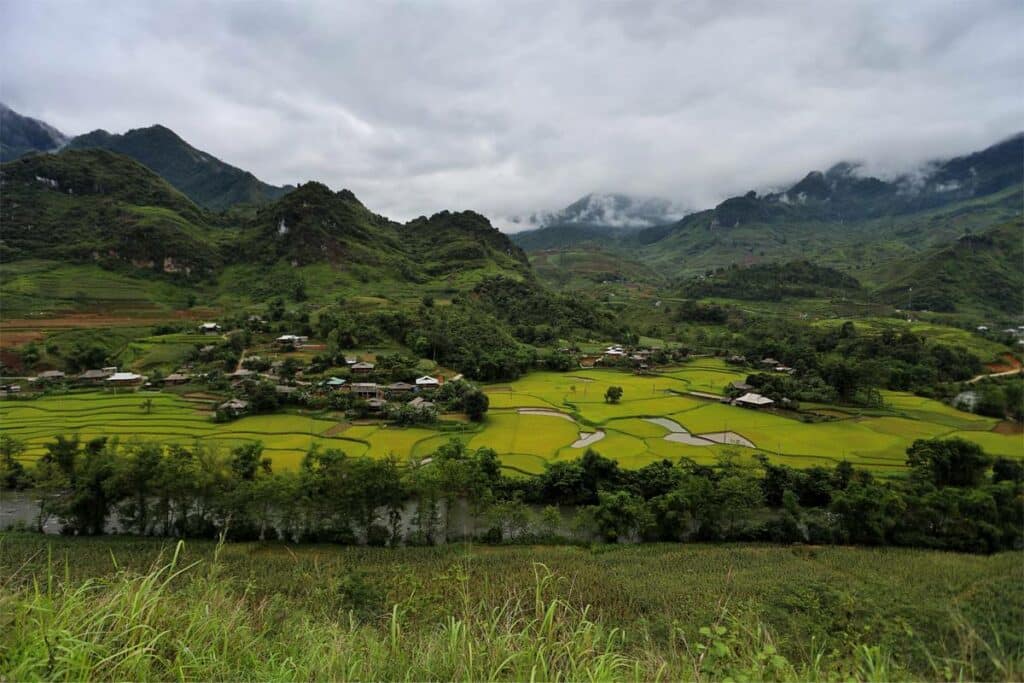
Du Gia is an unknown quiet village in Ha Giang. This place is visited almost exclusively by travelers who do the Ha Giang loop in 5 days or more. The best thing about this place is the peaceful and unspoiled beauty with its majestic natural landscape of mountains and rice paddies around it. In addition, the local people here are exceptionally hospitable and friendly.